About this site
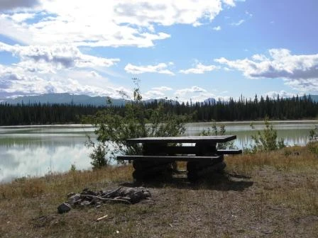
Source ↗Pinto Lake recreation site provides a picturesque location for a picnic or overnight stay that is conveniently located along the famous Highway 20 in the Chilcotin region. Pinto Lake is a small, shallow lake that is often a pretty green color. From here you can admire the spectacular views of the snow-capped peaks in the Niut Range of the Coast Mountains to the southwest, including Niut (?Eniyud) Mountain, White Saddle Mountain, Butler Peak, Razorback, and Blackhorn Mountain. Because Pinto Lake is quite small and shallow, it is not suitable for boats, but kayaks, paddleboards, canoes or oth…
LakePit toilet
Where it is
51.9085, -124.5289Loading map…
Rec Site
Weather forecast
next 14 daysThu29°12°0%
Fri25°12°4%
Sat22°11°39%
Sun18°8°53%
Mon17°7°16%
Tue17°8°41%
Wed23°5°2%
Thu23°8°2%
Fri24°8°6%
Sat22°11°25%
Sun20°9°8%
Mon21°6°12%
Tue18°12°12%
Wed23°11°12%
Fire & air quality
Nearest fire 86 km · 3 ha
Fire ban in effect · Cariboo
Air quality · Moderate (AQI 75)
Worst PM2.5 24.7 μg/m³, check local advisories
Drive from Kelowna, BC
drive (one-way)
660 km
drive time
9h 3m
round-trip
$261
158.4 L
Routed on real roads. Fuel at your current gas price.
Around this site
Fuel 5 km· West Chilcotin Trading LTDTown 22 km· Kleena KleeneLake 0 km· Pinto LakeHot spring 154 km· Job Creek Warm SpringsTrailhead 144 km· Lost Lake Trailhead
Photos
Your visit notes (0)
Find similar by activity →abettercamper.com