About this site
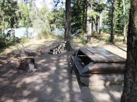
Source ↗The Davidson Bridge Recreation Site is situated on the shore of the stunningly beautiful blue waters of the Taseko River. Taseko is an anglicization of Dasiqox, the Tsilhqot'in name for this river. The Tsilhqot'in people refer to this spot on the river as "Dasiqox Nanatats'ededilh", meaning "Dasiqox ford/crossing".
FishingPit toiletLake
Where it is
51.5628, -123.6976Loading map…
Rec Site
Weather forecast
next 14 daysThu25°11°0%
Fri22°10°2%
Sat19°9°35%
Sun15°6°29%
Mon16°3°14%
Tue14°6°43%
Wed21°3°0%
Thu22°5°2%
Fri22°6°6%
Sat19°8°26%
Sun17°8°23%
Mon18°5°12%
Tue17°9°15%
Wed18°9°16%
Fire & air quality
Nearest fire 86 km · 7,000 ha
Fire ban in effect · Cariboo
Air quality · Moderate (AQI 75)
Worst PM2.5 15.4 μg/m³, check local advisories
Drive from Kelowna, BC
drive (one-way)
611 km
drive time
10h 14m
round-trip
$242
146.6 L
Routed on real roads. Fuel at your current gas price.
Around this site
Fuel 20 km· Xeni Gwet'in Gas StationTown 20 km· XeniLake 17 km· Konni LakeHot spring 101 km· Job Creek Warm SpringsTrailhead 118 km· Semaphore lakes trailhead
Photos
Your visit notes (0)
Find similar by activity →abettercamper.com